A hotel team has one afternoon to capture a lobby before guests return, a phone in one hand and a scanner quote in the other. The marketer wants stone, brass, and evening light to look true on a booking page. The project manager wants a doorway width that survives a tape measure. Choosing between Photogrammetry vs LiDAR on headline accuracy alone serves neither person. The useful question is simpler and harder. Which errors will a viewer, buyer, or contractor notice, and which capture creates less rework once the team leaves the room?
Table of Contents
- Why the Accuracy Debate Misleads Tour Teams
- Photogrammetry and LiDAR Compared Side by Side
- How Accuracy and Coverage Actually Differ
- Where Vegetation and Ground Change the Winner
- When a Cheap Capture Becomes Expensive
- How Capture and Processing Actually Run
- Match the Method to the Property Claim
Why the Accuracy Debate Misleads Tour Teams
The same lobby can produce two honest deliverables and two different failures. A photogrammetry build may render the veined stone and upholstered banquettes beautifully, then leave a white wall soft, incomplete, or slightly misplaced. A LiDAR build may hold the room's proportions with confidence, then look flat where color and material were supposed to persuade a guest to book.
Two Measurements, Two Failure Modes
Photogrammetry reconstructs geometry by matching visual features across overlapping photographs and working out where each camera stood. LiDAR measures distance directly with timed laser pulses. Both can produce dense point clouds, but one depends on what the camera can see and match, while the other depends on laser returns reaching a surface and coming back.
That distinction decides where trouble appears. Photogrammetry struggles on plain, glossy, dark, or repetitive surfaces because matching needs visible detail. LiDAR handles those surfaces more dependably for geometry, but it doesn't capture material appearance on its own. A viewer notices muddy fabric and invented reflections. A contractor notices a wall that sits several centimetres from its real position.
Who This Choice Actually Serves
Real estate agencies, architects and developers, hotels and hospitality teams, restaurants and venues, and photographers don't publish point clouds for their own sake. They publish claims about a space, whether that claim is atmosphere, capacity, access, or dimension. Property teams flying drones for exteriors in Australia should also check current Australian RPAS requirements before capture, since legal clearance is part of job planning, not an afterthought.
The situational rule: Photogrammetry when appearance has to sell the space, LiDAR when geometry has to hold, and a hybrid when a wrong metre could change a lease, a renovation, or buyer confidence.
The comparison that follows puts coverage, error, texture, and range in one table. Later sections test those numbers against vegetation, cost, field workflow, and the specific property claim a team intends to publish.
Photogrammetry and LiDAR Compared Side by Side
A hotel team choosing a capture method should ask what a guest will notice first: a finish that looks wrong, or a wall that sits several centimetres out of place. The table compares the trade-offs. Neither sensor wins every room.
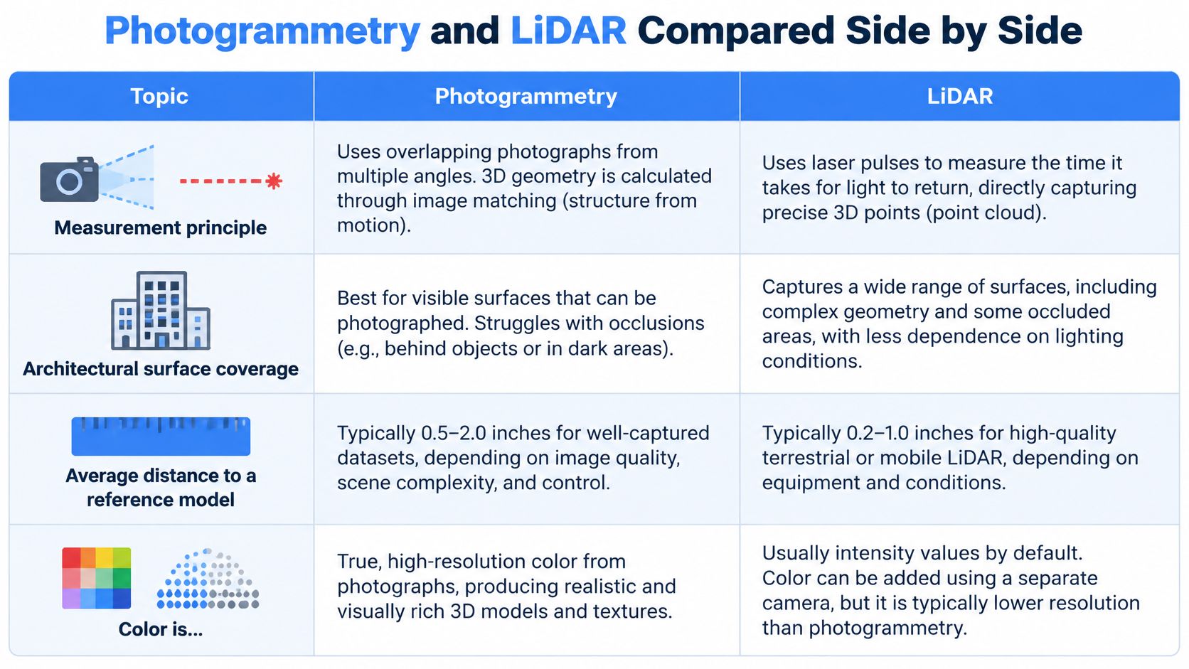
Photogrammetry vs LiDAR At a Glance
| Criterion | Photogrammetry | LiDAR |
|---|---|---|
| Measurement | Matching overlapping photos | Laser pulse distance |
| Architectural surface coverage | Varies with the scene and capture conditions | Varies with the scene and capture conditions |
| Average distance to reference | Depends on the camera and control conditions | Depends on the scanner and control conditions |
| Color and texture | Captured in the photographs | Requires separate imagery |
| Medium vegetation vertical RMSE | Varies with vegetation and capture conditions | Varies with vegetation and capture conditions |
| 2025 close-range accuracy | Depends on the camera and setup | Depends on the device and setup |
| Practical phone range | Depends on the camera and scene | Depends on the device and scene |
| Primary job | Visual realism of exposed surfaces | Geometric coverage and dimensions |
The comparative architectural study reports the coverage and distance results for its tested sensors and conditions. The UAV LiDAR and imagery study compares vegetation RMSE. Treat both as study-specific results, not guaranteed performance for a different camera, scanner, site, or capture setup.
How To Read the Rows
For a walkthrough meant to sell finishes, prioritize the photographs. Their color and material detail help buyers and guests judge the space. Camera choice still matters, so teams comparing capture hardware can review real estate 3D camera options before deciding what to use in each room.
For geometry on dull, dark, glossy, or repetitive surfaces, LiDAR can measure where image matching may struggle. But a dense model is not automatically a useful marketing tour. Pair laser geometry with imagery when the viewer needs both credible dimensions and convincing finishes.
A scan that looks complete isn't automatically true, and a scan that measures true isn't automatically persuasive.
Choose by the claim the tour needs to support. A marketing tour depends heavily on color and close-range detail. A measured model depends more on coverage and distance to reference. If both matter, plan for a hybrid workflow rather than expecting one sensor to do both jobs well.
On exterior work, vegetation deserves special attention. A courtyard tour may need to show the planting clearly, while a building survey may need ground measurements beneath or around trees. Decide which result matters before choosing the capture method.
How Accuracy and Coverage Actually Differ
Photogrammetry builds three-dimensional geometry from overlapping photographs, while LiDAR measures distances directly, and the comparative architectural study behind the headline figures reported more than 99% surface coverage for LiDAR against 55% to 81% for photogrammetry. The same study reported average distances from the reference model of approximately 2.8 to 3.0 cm for LiDAR, compared with 7 to 14 cm for photogrammetry. Those numbers describe geometric completeness and placement, not whether a scene looks convincing.
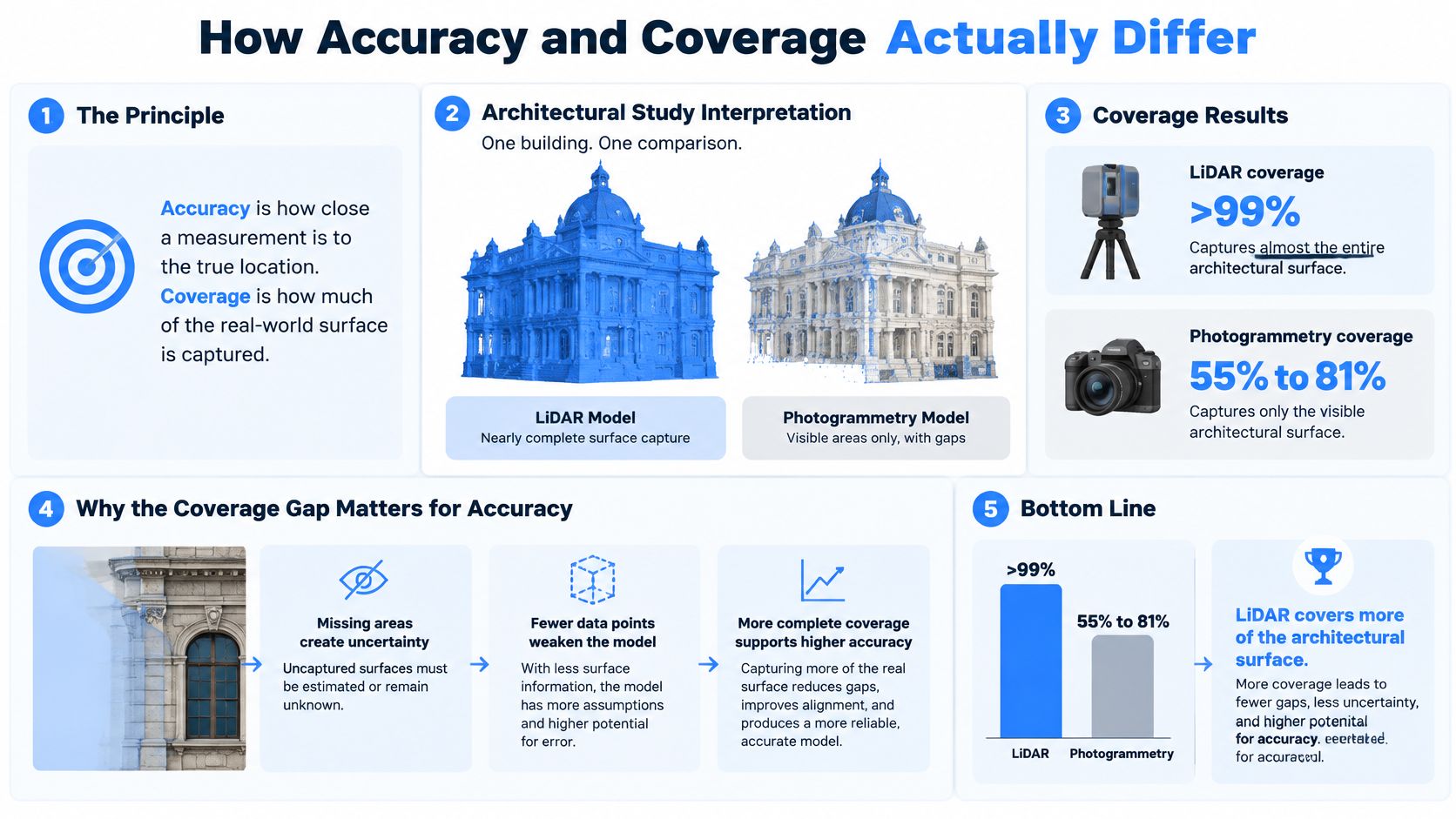
What Several Centimetres Look Like In a Room
A wall displaced by several centimetres betrays itself at edges. Door frames stop aligning cleanly. Built-in joinery appears to float or sink into plaster. A floor plan derived from that mesh misstates clearance, and anyone pricing fitted furniture or checking access inherits the error.
A texture failure betrays itself differently. Stone loses its veining, fabric turns to smear, and timber reads as printed plastic even when the underlying mesh is complete. Viewers may not know the word photogrammetry, but they know when a premium room looks cheap. That's why the coverage gap and the visual gap must stay separate in a Photogrammetry vs LiDAR decision. LiDAR wins the first. Photographs usually win the second.
Where Indoor Surfaces Break Each Method
Weak texture, repetitive patterns, and difficult lighting explain much of the photogrammetry shortfall. White walls offer few features to match. Repeating tiles offer too many similar features, so the software can lock onto the wrong one. Glossy stone changes appearance as the camera moves, which breaks the assumption that a point looks the same from every angle.
- Mirrors and glass: Reflections can invent space behind a surface, and transparent panels may record whatever sits beyond them.
- Dark ceilings and shadowed corners: Low light starves image matching of usable detail, so surfaces drop out or turn noisy.
- Furniture occlusion: Sofas and beds hide the floor and wall junctions the reconstruction needs to close a room.
- Long feature-poor corridors: Image matching loses orientation, and mobile LiDAR tracking can drift when nothing distinctive anchors position.
LiDAR reduces the texture problem because laser distance doesn't depend on a surface looking detailed. It doesn't abolish physics. Glass, mirrors, and very dark or reflective materials can still corrupt returns, and a scanner still can't measure a wall hidden behind a wardrobe. Direct measurement is more dependable, not magic.
Validation habit: Before publishing any dimension, check one known length with a tape, one glossy surface for invented geometry, and one occluded corner for holes.
That three-point check takes minutes and catches the failures viewers and contractors notice first. It also keeps teams honest about scope. These study centimetres shouldn't be treated as universal benchmarks, because camera or scanner quality, control points, processing software, object scale, lighting, and surface properties all move the result. A controlled photo set in a textured room can perform far better than the weak end of the range. A rushed scan in a mirrored bathroom can perform worse than either figure suggests.
Where Vegetation and Ground Change the Winner
Outdoors, the surface rewrites the ranking. Bare, textured ground gives photographs plenty to match. Leaves give photographs a moving, repetitive surface that hides the ground a client may need. LiDAR pulses can pass through gaps in foliage and return from below, while image reconstruction can only build what appears visibly in the frames.
Precision Is Not the Same As Beating Photographs
In the U.S. Geological Survey analysis described in the ISPRS comparison paper, same-surface, intraswath precision for airborne LiDAR was better than 1 cm in most cases. The same source notes that 99% of western study-area tiles had root-mean-square difference values of 0.04 m or less, while the eastern area reached 0.026 m or less. Those figures show LiDAR agreeing with itself across overlapping passes. They don't, on their own, prove superiority over a controlled photo set on open ground.
The Colorado monitoring evaluation in that same comparison makes the point plainly. Both high-resolution LiDAR and photogrammetry met a target vertical accuracy of 20 cm on bare sand, whereas neither met that target reliably on vegetated sand. On vegetated surfaces, the best results were approximately 35 cm accurate, and photogrammetry produced volumetric results within 3% on bare ground and 4 to 9% on vegetated ground.
The Vegetation Height Penalty
A separate terrain benchmark in the UAV LiDAR and imagery study found low vegetation produced vertical RMSE values of 0.11 m for UAV LiDAR and 0.14 m for UAV imagery. Medium vegetation increased photogrammetric RMSE to 0.36 m while LiDAR remained at 0.11 m. The study observed an approximately 0.10 m photogrammetric accuracy decrease for every additional 20 cm of vegetation height, with no equivalent dependency for LiDAR.
Plants don't just decorate an exterior capture. Taller planting steadily taxes photographs while leaving laser ground returns largely alone.
For a hotel approach, hedged courtyard, or tree-lined facade, the booking follows the claim. Teams publishing ground levels, drainage falls, boundary features, or the true wall line behind planting should choose LiDAR. Teams publishing the look of a clear, hard-surfaced, well-textured courtyard can stay with controlled photographs, provided overlap and light are managed properly.
Before either cloud gets published, one bare patch and one planted edge deserve direct checks against known points. Agreement on open paving proves very little about performance under a hedge. That single habit prevents a common exterior mistake, validating the easy surface and shipping the hard one unchecked.
When a Cheap Capture Becomes Expensive
A phone may cost nothing to use, but a weak capture can still create expensive rework. Professional scanners cost substantially more than phone-based photogrammetry, and paid scan apps add recurring costs. Compare the full project cost, including access to equipment, processing time, reshoots, and the consequences of publishing the wrong level of detail.
What the Capture Actually Costs
| Cost item | Photogrammetry | LiDAR or hybrid |
|---|---|---|
| Hardware | Phone or DSLR, highly portable | LiDAR phone or professional scanner, with higher equipment costs |
| Software | May use low-cost or free tools | Paid scan apps add recurring costs |
| Example field output | Depends on overlap, texture, and control | Depends on the equipment, site, and capture requirements |
| Hidden project cost | Reshoots, hole filling, scale correction | Hardware access, indoor drift, unused precision on a visual-only tour |
The False Economy, Itemised
A photo-only capture of a pale, window-heavy show apartment can look cheap until the glass blows out and the team has to return. White walls may need manual cleanup. Without a reliable scale reference, the floor plan waits while someone goes back with a tape. The camera was effectively free. The project wasn't.
- Device access: A phone may already be available, but LiDAR depends on the smartphone model.
- Subscriptions: Paid scanning apps add recurring costs.
- Field and processing hours: Overlap planning, alignment, cleanup, and hole filling take skilled time.
- Reshoots: Missed texture, poor light, and absent control can require another visit.
- Business cost: A misleading scene can contribute to a lost lease, a flawed renovation takeoff, or a guest arriving at a room that differs from the tour.
The reverse mistake wastes money too. Survey-grade LiDAR is hard to justify for a hotel gallery whose purpose is to show guests what the space looks like. A bare laser model without good imagery can also fail as a marketing asset, even when the equipment costs more.
Phone-based capture has limits on large exteriors and atriums. If the deliverable claims measured accuracy beyond what the capture can support, the cost of a dispute and resurvey can exceed the savings from choosing a phone.
Price the rework, not the camera. Equipment is one line. Hours, retakes, cleanup, and the cost of a wrong claim finish the invoice.
Hybrid mobile capture can reduce labor across a large site when its speed and measurement capabilities fit the job. It does not make every phone a survey instrument. Choose the workflow that produces a publishable result with the least return travel and manual repair.
How Capture and Processing Actually Run
A tour of a furnished suite and a model for checking dimensions need different outputs, even when the crew starts in the same room. Set the deliverable first. Then choose the capture branch, plan the checks, and process for what the viewer or client must judge.
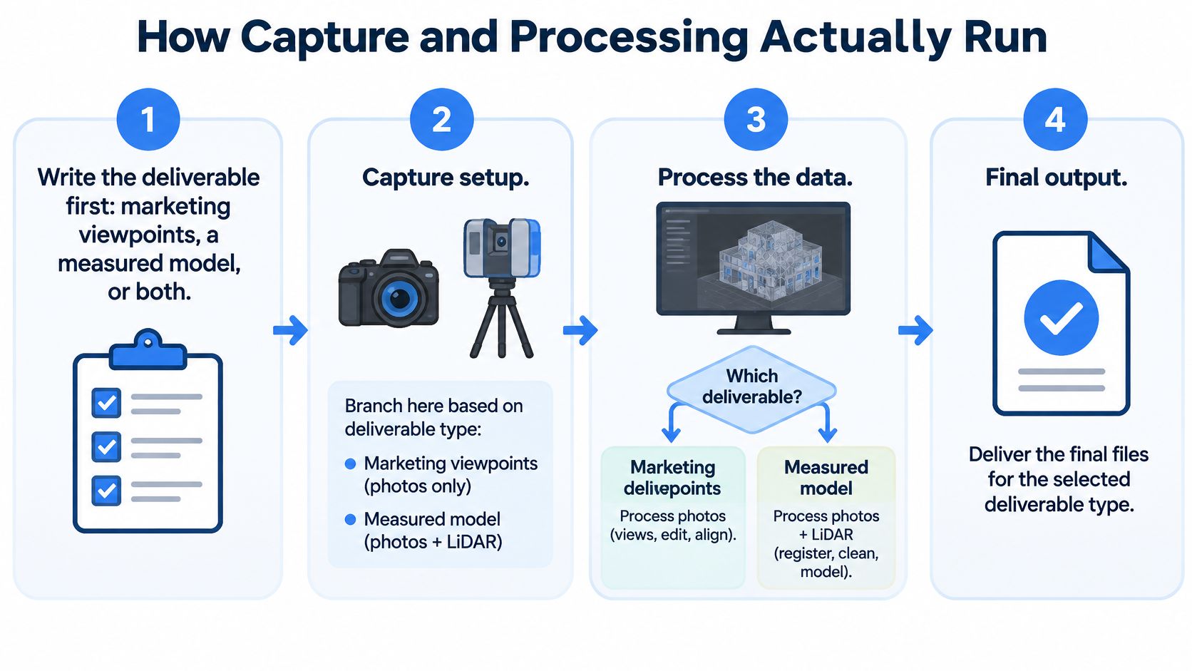
One Field Sequence With a Branch
- Define the deliverable. A marketing tour needs clear viewpoints and an intuitive route. A measured model needs scale and coordinates. If the same capture must serve both, plan for each before entering the property.
- Capture photographs with control. Use high overlap, stable lighting, and textured surfaces. Add ground or scale control where dimensions matter. In the UAV topographic benchmark, ground-control points reduced average absolute position error from 0.12 m to 0.05 m and RMSE from 0.03 m to 0.01 m.
- Capture LiDAR with overlapping stations. Overlap helps limit tracking drift in empty corridors. Capture paired color imagery when material and finish will matter to the viewer. The benchmark LiDAR datasets contained approximately 300 million and 1 billion points, with 0.031 m mean absolute distance and 0.019 m distance RMSE.
- Process, then check scale. Align the data, remove outliers, and inspect holes and reflective surfaces. Verify scale against a tape measurement or control point before export.
- Export for the audience. Measurement users need a mesh or point cloud with coordinates. Tour viewers need a clear route, useful hotspots, and a considered starting view.
A survey cloud serves measurement. A tour serves a person deciding whether to visit, book, or buy. Choose the output around that decision.
Exterior work adds flight planning, permissions, and ground control across the site. Teams considering aerial capture can review drone aerial mapping workflows when scoping the job. Indoors, a scale bar or taped doorway gives photo reconstruction a reference that pixels alone cannot provide.
Documentation discipline matters after capture. Teams recording existing conditions for claims or remedial planning may find inspection guidance for NC and VA policyholders useful context for how inspection records get used beyond the shoot itself. Record control locations, check dimensions, and known problem surfaces so the deliverable can be assessed later.
Photogrammetry suits visually rich interiors and exteriors when overlap, texture, stable lighting, and reliable control are in place. Weak capture turns processing into repair work. LiDAR depends less on texture and light, but still needs station planning and drift checks. Confirm scale independently before making a measured claim.
Match the Method to the Property Claim
A tour can sell a room, document a renovation, or support a dimensional decision. Choose capture based on what the viewer will notice if the result is wrong, and whether a cheaper method could create costly rework.
For furnished listings, hospitality spaces, architecture, and wooded exteriors, the right method depends on the claim. Mobile capture loses precision at longer distances, and smartphone LiDAR is better suited to short ranges.
Furnished Listings and Hospitality Spaces
A furnished listing is judged on finishes, light, and proportion as they appear on screen. Photogrammetry or strong ordinary photographs suit texture-rich, close-range rooms. Virtual Tour Easy can turn ordinary phone or DSLR photos into 360° scenes and video, with no 360° camera required.
Hotels, restaurants, venues, schools, and tourism attractions face the same persuasion test. A lobby or guest-room tour should convey atmosphere. Add LiDAR when dimensions such as ballroom length or ceiling height support a specific claim. AI-generated scenes are illustrative and may not accurately represent a real property. Customers are responsible for how they present them, so do not attach measured claims to illustrative imagery.
Architecture, Renovation, and Wooded Exteriors
For architecture and renovation, a doorway measurement can affect construction, and an accessibility review depends on dimensions rather than visual appeal. Use LiDAR or controlled photogrammetry, record check dimensions, and maintain as-built documentation. A tour file is not a substitute for a formal valuation or survey, including when a property valuation is required.
Indoor limits still apply. LiDAR can lose tracking and drift in feature-poor environments. Photogrammetry needs visual features or control points to orient reliably. A long, blank corridor captured on a phone is not a survey.
For wooded or occluded exteriors, use LiDAR when ground or wall lines behind planting must be represented accurately. Laser returns can capture surfaces that image matching cannot see; photographs add color and material detail. In a hybrid, LiDAR or scale control establishes geometry, while photographs provide visual context.
The Booking Rules
- If the viewer must want the room, use photogrammetry or ordinary photos. Keep measured claims off the tour.
- If a contractor or accessibility reviewer will measure the file, use LiDAR or controlled photogrammetry, and record a check dimension.
- If a wrong length could affect a lease, fit-out, or buyer confidence, budget for suitable measurement rather than relying on a cheap photo set.
Neither a photo set nor a laser is automatically the right choice. Match the method to the claim.
For tours focused on appearance, Virtual Tour Easy turns ordinary phone or DSLR photos into 360° scenes and video without a specialized camera. Real estate, hospitality, and venue teams can create tours while reserving LiDAR for work with dimensional claims. First decide what the tour must support, then choose the capture method that limits noticeable errors and avoidable rework.